Methodology
SustainGenix Frameworks bridge the gap between high-level policy advisory and ground-level implementation
The Double Materiality Approach
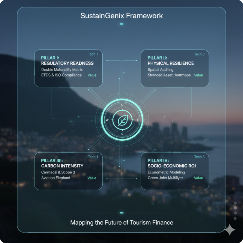
Our work is built on a 4-Pillar Forensic Architecture designed to future-proof National Tourism Organisations (NTOs), development partners, and private investors against the 2026 regulatory shift.
Incorporating Double Materiality throughout, we utilise a comprehensive GeoSpatial Auditing approach to identify climate and social related risks and opportunities to formulate a Climate-Resilient Scorecard.
Proprietary Tools:
The NTO Resilience Scorecard:
A 360-degree diagnostic for destinations.
The Carmacal Logic
High-resolution Scope 3 carbon intensity modelling.
Stranded Asset Modelling
Visualising terrain vulnerability and infrastructure risk
The 10-Point Resilience Checklist for National Tourism Resilience
1. Spatial Visibility: Do you possess a 1m-resolution Digital Twin of your top three tourism "Engine Rooms"?
2.Asset Vulnerability: Have you calculated the "First-Floor Elevation" risk for 100% of your coastal hotel inventory?
3. Connectivity Redundancy: Can your primary tourism circuits function if their "Single Point of Failure" (bridge/pass) is compromised for >48 hours?
4. Carbon Exposure: Is your CO2-to-Revenue ratio (CRR) being tracked against upcoming international aviation taxes?
5. Biological Liquidity: Is your "Natural Capital" (reefs/forests) depreciating faster than your marketing spend can replace it?
6. Thermal Viability: Have you mapped the "Human Comfort Hours" (HCH) for your heritage sites through 2040?
7. Institutional Muscle: Is your GIS department integrated into your Ministry of Finance’s budgeting cycle?
8. Insurance Security: Are your primary assets still insurable under a "High-Emission" (SSP5-8.5) climate scenario?
9. Legislative Agility: Does your NTO have the legal mandate to enforce "Adaptive Zoning" in high-risk zones?
10. Data Sovereignty: Do you own the raw data behind your resilience maps, or is it locked in a proprietary vendor's cloud?
If you answered 'No' or 'Unknown' to more than three of these questions, your destination is harbouring unmapped liabilities.
GIS Spatial Auditing
High-Altitude & Coastal Resilience The GIS Spatial Auditing Framework
1. Executive Summary: The Resilience Imperative
As global climate volatility accelerates, the traditional models of tourism management, reliant on static annual arrivals and historical weather patterns, have become obsolete. For nations with significant high-altitude (mountain) or low-lying (coastal) tourism assets, the risks are no longer theoretical; they are financial and existential.
GIS Spatial Auditing represents a fundamental shift from reactive crisis management to proactive strategic foresight. By creating a 'Digital Twin' of a destination's physical and socio-economic landscape, spatial auditing provides:
For Mountain Regions: Precision modelling of Glacial Lake Outburst Floods (GLOFs), landslide susceptibility, and "Dead-End" corridor risks for trekking circuits.
For Coastal Regions: Forensic mapping of sea-level rise (SLR), storm surge inundation, and the identification of Stranded Assets—infrastructure that will lose economic viability before its debt cycle is retired.
The Bottom Line: This framework transforms raw geospatial data into a National Resilience Dashboard, allowing policymakers to implement "Dynamic Carrying Capacities" that protect ecological integrity while securing long-term investor confidence.
Climate-Resilient Scorecard
Executive Summary The Forensic Resilience Mandate
The Challenge: Global tourism is facing a structural decoupling from its physical environment. As climate volatility accelerates, traditional National Tourism Strategies (NTS), which rely on marketing and reactive crisis management, are becoming obsolete. Destinations are currently harbouring 'Unmapped Liabilities' in the form of stranded infrastructure, uninsurable coastal assets, and destabilised mountain
The Solution: This Technical Series introduces the Climate-Resilient NTO Scorecard (Rc) and a Geospatial Forensic Workflow. We propose a shift from "Sustainability" (impact on the planet) to "Resilience" (the planet’s impact on the industry). By utilizing open-source QGIS, high-resolution LiDAR, and multi-spectral satellite auditing, National Tourism Organisations (NTOs) can quantify their physical and financial exposure with 1-meter precision.
Key Institutional Outcomes:
Risk-Weighted Asset Management: Identifying which tourism hubs are 'Bankable' over a 30-year climate horizon. Fiscal Stability: Pre-empting the 'Stranded Asset' crisis that threatens sovereign credit ratings in tourism-dependent nations. Access to Climate Finance: Aligning with World Bank and IMF standards to unlock Green/Blue Resilience Bonds.
Conclusion: The destinations that thrive in the 21st century will not be the ones with the best marketing, but the ones with the most accurate maps. This repository provides the architecture to build those maps.
Our work is built on a 4-Pillar Forensic Architecture designed to future-proof National Tourism Organisations (NTOs), development partners, and private investors against the 2026 regulatory shift.
Incorporating Double Materiality throughout, we utilise a comprehensive GeoSpatial Auditing approach to identify climate and social related risks and opportunities to formulate a Climate-Resilient Scorecard.Glossary of Key Terms
Glossary of Forensic Resilience & Geospatial Auditing
A. Core Resilience Terms
Adaptive Capacity (AC): The institutional muscle of a nation; its budget, governance, and technical ability to adjust to climate damage. Climate-Resilient NTO Scorecard (Rc): A forensic tool that aggregates physical, financial, and natural capital risks into a single grade for institutional investors. Managed Retreat: A strategic policy where communities or infrastructure are moved away from high-risk zones (e.g., eroding cliffs) before a catastrophic failure occurs. Resilience Gap: The delta between a nation's stated climate goals and its actual spatial readiness on the ground.
B. Geospatial & Technical Terms
Bathymetry: The study of underwater depth (the 'topography' of the ocean floor), critical for modelling how storm surges will hit a coast. Digital Twin: A 1:1 digital replica of a physical asset or landscape used to run 'What-if' disaster simulations in QGIS. InSAR (Interferometric Synthetic Aperture Radar): Satellite tech that detects millimetre-scale movement in the ground, vital for monitoring 'creeping' landslides under hotels. LiDAR (Light Detection and Ranging): Laser-based mapping that provides ultra-high-resolution 3D models of terrain, penetrating forest canopy to find hidden flood paths. NDVI (Normalised Difference Vegetation Index): A satellite-derived metric used to monitor the Biological Integrity of forests and reefs in real-time.
C. Financial & Forensic Terms
Blue Carbon: The carbon captured by the world's ocean and coastal ecosystems (mangroves, seagrass), which can be monetised to fund coastal resilience. Carbon-to-Revenue Ratio (CRR): A forensic metric measuring the kilograms of CO2 emitted per $1 of tourist spend. Stranded Asset: A tourism asset (like a resort or airport) that loses its value prematurely due to physical climate damage or being rendered inaccessible. Transition Risk: The financial risk arising from the shift toward a low-carbon economy, such as new carbon taxes on long-haul flights.
D. Legal Statement: Privacy & Sovereignty Mandate
We take your organisation’s privacy seriously and we will not share sensitive infrastructure data. We understand our role in partnerships as Data Stewards rather than simply a Vendor.
1. Data Sovereignty & Jurisdictional Integrity
All geospatial data, including LiDAR clouds, InSAR displacement maps, and cadastral overlays processed through our Forensic Multi-Pillar Methodology, remain the absolute and exclusive property of the Sovereign State. Our organisation acts solely as a technical processor. We do not claim ownership of, nor will we sell, trade, or utilise national tourism data for third-party commercial gain without explicit cabinet-level authorisation.
2. The 'Air-Gap' Security Protocol
For sensitive infrastructure audits (airports, power grids, heritage vaults), we provide an 'Air-Gap' option. Technical audits can be performed on local, non-networked servers within the NTO’s jurisdiction to ensure that critical vulnerability maps are shielded from international cyber-intelligence harvesting.
3. Privacy & Non-Identification
While our audits are Forensic, they focus on Systems and Assets, not individuals. We adhere to GDPR and ISO/IEC 27001 standards. Any socio-economic mapping used to calculate Adaptive Capacity is anonymised and aggregated to prevent the identification of private citizens or individual business owners.
4. Liability Limitation on Projections
Climate modelling is an exercise in probability, not prophecy. Our Resilience Coefficient (Rc) utilises the CMIP6 ensemble to provide the highest-fidelity risk estimates possible. However, the Sovereign State acknowledges that non-linear climate shifts (e.g., rapid glacial collapse) may exceed current modelling capabilities. This data is for Strategic Decision Support and does not constitute a legal guarantee of asset safety.
Reference List
1. Institutional Frameworks (Risk & Finance)
Financial Stability Board (FSB) (2025). Task Force on Climate-related Financial Disclosures (TCFD): 2025 Status Report on the Hospitality and Tourism Sector. [The gold standard for "Transition Risk" and "Physical Risk" definitions].
Network for Greening the Financial System (NGFS) (2024). Scenarios for Monetary and Financial Stability: Focus on Tourism-Dependent Emerging Markets. [Technical basis for the "Macro-Economic Stress Test"].
International Monetary Fund (IMF) (2024). Article IV Consultation: Assessing Climate Vulnerability in Small Island Developing States. IMF Country Reports. [Methodology for "Fiscal Buffer" assessment in the IAC Pillar].
World Bank / GFDRR (2023). Unlocking Financial Resilience: A Roadmap for Sovereign Risk Financing. [Basis for the "Insurance Optimization" section].
2. Geospatial & Ecological Science (The "Physics" Layer)
IPCC (2023). Sixth Assessment Report (AR6): Climate Change 2023: Synthesis Report. [The source for CMIP6 climate models used in the PAE Pillar].
European Space Agency (ESA) (2025). Copernicus Land Monitoring Service: High-Altitude Permafrost and Snow Cover Dynamics 2020-2025. [Technical data for the Mountain Typology].
Dasgupta, P. (2021). The Economics of Biodiversity: The Dasgupta Review. HM Treasury. [The foundational text for "Natural Capital Liquidity" and "Biological Depreciation"].
Costanza, R., et al. (2024). "Changes in the Global Value of Ecosystem Services." Global Environmental Change. [Provides the valuation constants for the NCL Pillar].
3. Tourism Economics & Adaptive Capacity
Gössling, S., & Higham, J. (2024). The Low-Carbon Transition in Tourism: Economics and Policy. Routledge. [Citations for the "Carbon-to-Revenue Ratio" (CRR) metric].
Scott, D., & Steiger, R. (2025). "Climate Change and the Future of the Global Tourism Geography." Journal of Sustainable Tourism. [Basis for the "Winter Compression" and "Human Comfort Hours" metrics].
UN Tourism (2025). Climate Action in Tourism: Measuring the Gap between Policy and Infrastructure Investment. [Technical data for the "Policy-Action Gap" forensic indicator].
4. Technical Standards for Remote Sensing (Forensic Tools)
Open Geospatial Consortium (OGC) (2024). Standards for Digital Twins in Disaster Risk Management. [Framework for the "Digital Twin" construction in Phase 1].
Sentinel-Hub (2025). Technical Guide for NDVI and NDWI (Water Index) Integration in Urban and Coastal Planning. [The manual for the Forensic "Typology" maps].
We don't just report on the climate transition; we provide the tools for communities to lead it
SustainGenix GmbH
Marie-Curie-Straße 8,
D-79539 Lörrach, Germany
Commercial Register: Amtsgericht Freiburg i. Br. HRB 730031
Tax number: 11087/29562
VAT ID: DE365116198
E: info (@) sustaingenix.com
T: +49 160 339 4661
Useful Link
follow us:
I have read and understood privacy and cookies Policy and ready to join the mailing list.
Copyright © 2026 sustaingenixgmbh. All Rights Reserved.